9Apps is your first choice to download apps. 20,000+ users downloaded Martley latest version on 9Apps for free every week! With unexpected, recently it has become very popular in India. This hot app was released on 2018-06-19. Don’t be hesitate, download and install it on your mobile phone now!
A guide to the route and geology of the Martley to Alfrick section of the Abberley and Malvern Hills Geopark Way. This long distance trail covers 109 miles from Bridgnorth in Shropshire to Gloucester Cathedral.
All revenue from the sale of the app is donated to the Geology Trusts who have created and maintain this walk.
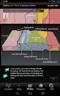
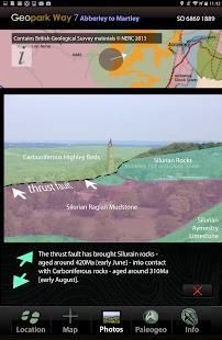
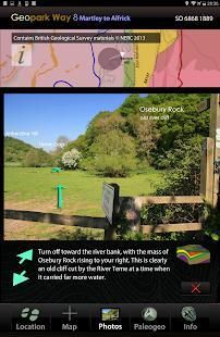
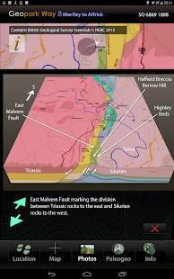
The 11.8km walk is mainly over the Triassic rocks of the Worcestershire Basin - a huge fault bound rift structure filled with upto 3km depth of Permian and Triassic sediments deposited during arid times, when this area lay within the Pangea supercontinent. Around half-way through the walk you climb up over the Silurian spine of the Abberley Hills, to Ankerdine Hill, then down into Knightwick Gap, cut by glacial meltwaters. You pass under the distinctive Osebury Rock, formed of Permian breccia, back onto hop growing country over Triassic sediments, to reach the attractive village of Alfrick.
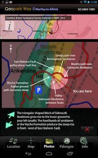
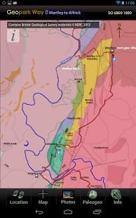
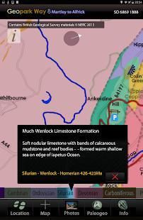
The app has 5 core views, the default is the Map of the trail, overlain on a geology map derived from the British Geological Survey DiGMapGB-50 (1:50,000 scale) data for the Martley to Alfrick area. You have this map built into the app, along with all the associated BGS data, which is then always available as you walk, served to your position by GPS or, by simply touching the map if using the app away from the area, or on a device without GPS. The map can be zoomed to x4.
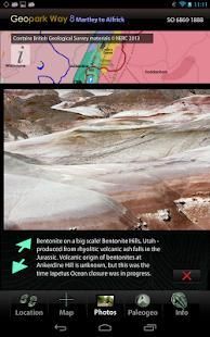
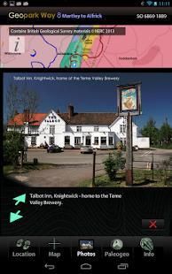
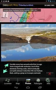
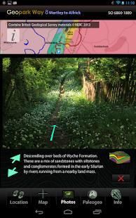
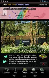
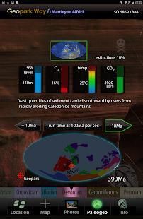
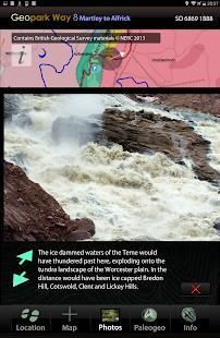
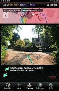
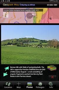
The Photos view contains a series of pictures taken along the walk, from the perspective of someone walking in either direction – you select which direction to view. When you use the app in the area, images and information relevant to your location are served to you. You can also virtually walk the path – perhaps to get a feel in advance of how challenging the terrain will be. Linked to the Photos view are 3D sections of the geology and reconstructions of ancient environments.
The Location view provides position data and optionally will record your walk and provide an updated estimate of how long to it will take you to complete.
The Information view provides links to the organisations, including the Herefordshire and Worcestershire Earth Heritage Trust, who founded and continue to promote and manage the Geopark and the trail.
The app has all required data loaded and does not require cellular or WiFi connectivity in the field – just a charged battery.
The app contains a great deal of detailed visual data and is optimally used in the field on devices with screen sizes in the 5 to 7 inch range – larger tablet screens are great too, but can be tiring to hold for a long time and are less easily stored away in a pocket or backpack.
Sebuah panduan untuk rute dan geologi dari Martley ke Alfrick bagian dari Abberley dan Malvern Hills Geopark Way. Jejak ini jarak jauh mencakup 109 km dari Bridgnorth di Shropshire Katedral Gloucester.
Semua pendapatan dari penjualan aplikasi ini disumbangkan kepada Trust Geologi yang telah menciptakan dan memelihara jalan ini.
The 11.8km berjalan terutama atas batu-batu Trias dari Worcestershire Basin - kesalahan struktur keretakan terikat besar yang dipenuhi dengan upto 3km kedalaman Permian dan Triassic sedimen diendapkan selama waktu kering, ketika daerah ini terletak dalam superbenua Pangea. Sekitar setengah jalan melalui berjalan Anda naik di atas punggung Silur dari Abberley Hills, untuk Ankerdine Hill, kemudian turun ke Knightwick Gap, dipotong oleh air lelehannya glasial. Anda lewat di bawah khas Osebury Rock, dibentuk dari Permian breksi, kembali ke negara berkembang hop atas sedimen Trias, untuk mencapai desa yang menarik dari Alfrick.
Aplikasi ini memiliki 5 views inti, default adalah Peta jejak, ditindih pada peta geologi berasal dari Survei Geologi Inggris DiGMapGB-50 (skala 1:50.000) data untuk Martley ke daerah Alfrick. Anda memiliki peta ini dibangun ke dalam aplikasi, bersama dengan semua data BGS terkait, yang kemudian selalu tersedia saat Anda berjalan, disajikan kepada posisi Anda dengan GPS atau, dengan hanya menyentuh peta jika menggunakan app jauh dari daerah tersebut, atau perangkat tanpa GPS. Peta dapat diperbesar ke x4.
The Tampilan Foto berisi serangkaian gambar yang diambil sepanjang jalan, dari perspektif seseorang berjalan di kedua arah - Anda memilih arah mana untuk melihat. Bila Anda menggunakan aplikasi di daerah, gambar dan informasi yang relevan dengan lokasi Anda disajikan kepada Anda. Anda juga dapat berjalan hampir jalan - mungkin untuk merasakan terlebih dahulu bagaimana menantang medan akan. Terkait dengan pandangan Foto adalah bagian 3D geologi dan rekonstruksi lingkungan purba.
The Lokasi Pemandangan menyediakan data posisi dan opsional akan merekam berjalan Anda dan memberikan perkiraan terbaru dari berapa lama itu akan membawa Anda untuk menyelesaikan.
Pandangan Informasi menyediakan link ke organisasi, termasuk Herefordshire dan Worcestershire Earth Heritage Trust, yang mendirikan dan terus mempromosikan dan mengelola Geopark dan jejak.
Aplikasi ini memiliki semua data yang diperlukan dimuat dan tidak memerlukan konektivitas seluler atau WiFi di lapangan - hanya baterai yang terisi.
Aplikasi ini berisi banyak data visual rinci dan secara optimal digunakan di lapangan pada perangkat dengan ukuran layar dalam 5 sampai 7 inci kisaran - layar tablet yang lebih besar terlalu besar, tetapi dapat melelahkan untuk terus untuk waktu yang lama dan kurang mudah disimpan di dalam saku atau tas.
Modifcations to geology map to incorporate recent work at Martley Rock.
Addition of Martley Geo-Village geology sites and walk routes.
Minor modifications to user interface.
9Apps 4.9