Welcome to our app recommend. 20,000+ users downloaded WhatsThat - Landscape Scanner latest version on 9Apps for free every week! Fortunately, It's easy to get this popular app. This hot app was released on 2015-12-31. You can enjoy the most completed function of this app.
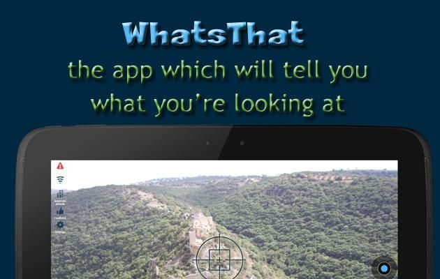
WhatsThat - Landscape Scanner: the application which will tell you what you’re looking at.
In an unfamiliar place and want to know what’s around you? Use your camera and find out!
Useful especially for navigating in new places, travelling in mountains, for trips in the city, and outside in the nature.
Includes built-in automatic distance measure/meter for long ranges.
Instructions:
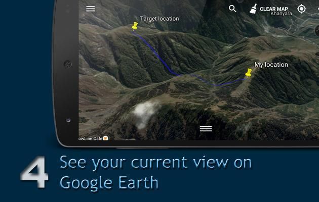
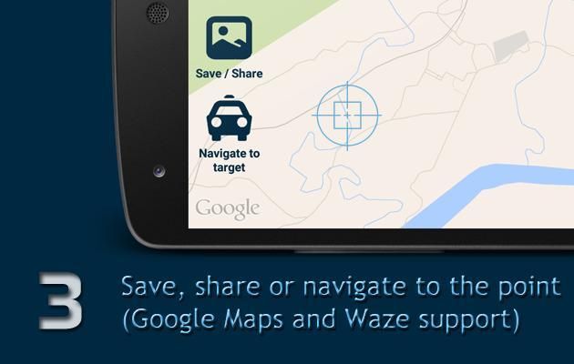
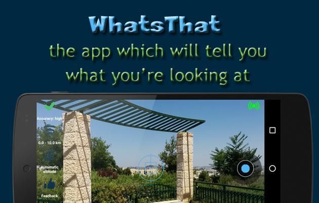
Hold your device horizontally.Within few seconds name and range of prominent places will be marked on the camera screen (Augmented Reality - AR). For any other location, point the sight/crosshair on the point you want to find out about, and take a photo (blue circle in the right of the screen). WhatsThat will calculate the point and mark it on the map.
Effective range: 100 meters - 10 km (~110 yards - 6.2 miles).
Additional features:
★ Augmented reality (AR) - prominent places are marked on the camera screen
★ Rangefinder/Milometer (distance indicated on the point on your map)
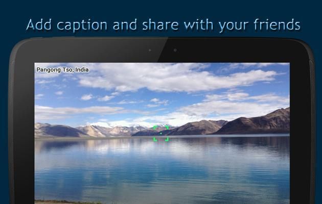
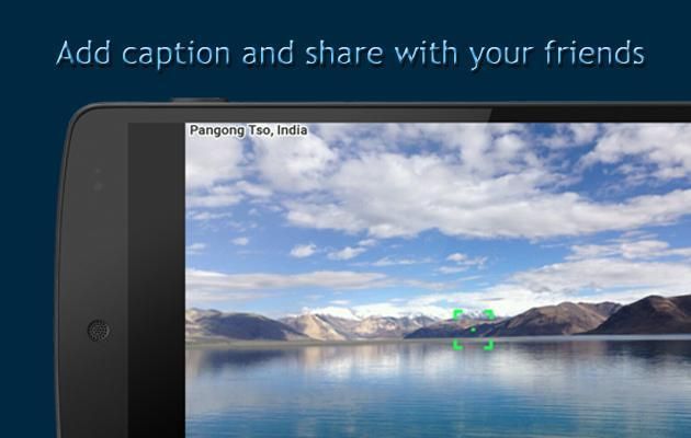
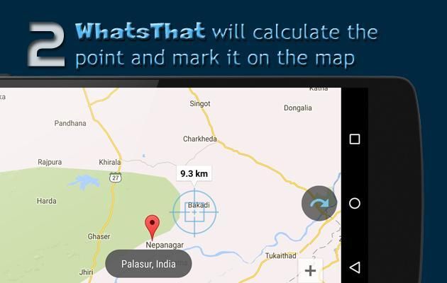
★ Share the photo, including text
★ Navigate to the point (Google Maps/Waze support)
★ Embedded high quality map (Google maps)
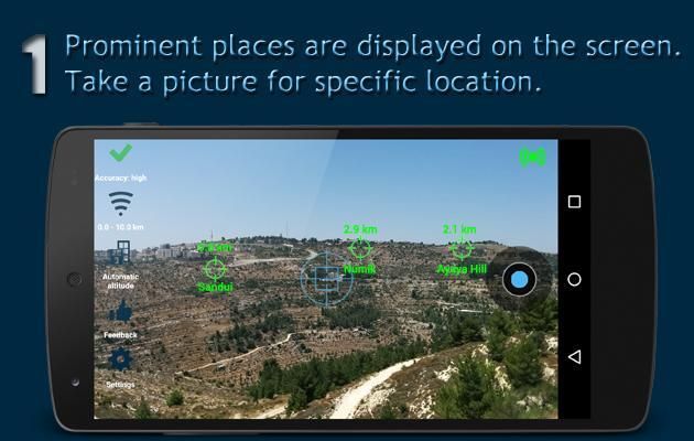
★ Google Earth integration: opens Google Earth app with the view of your location and target location and saves a file for opening in your PC or other device.
How does it work?
Augmented reality: WhatsThat detects prominent places around you. Based on your location and your device angle, WhatsThat marks them on the camera screen, so you see the places on your camera screen and a marker above then with the names of the places and its ranges.
When you take a photo, WhatsThat draws an imaginary parallel line from your camera lens to the ground. The app works under any lighting or other condition because it is based on the angle of your device, your location and the area’s topography. You will get the same answer in pitch black, behind a wall, etc.
Getting the best result:
• Ensure that your device’s reception is optimal: note the symbol in the top left corner of your camera display. It will go from green to yellow to red as reception weakens.
• Press the symbol for instructions on how to improve your reception.
• Make sure your compass is accurate. Keep the device away from metals and other things which may disrupt the compass
• Aim at a point on the ground. For example, if you are looking at a building, aim at the point at which the building meets the ground.
• Activate all location services: GPS satellites and wireless networks.
• Within a building or when GPS is not active specify your altitude (building icon on the left)
Accuracy:
WhatsThat’s accuracy is influenced by the accuracy of your GPS and other location services, your compass and movement sensor, and topographical databases. The average margin of error is 10%, given optimal device conditions - when GPS is working and your device compass is accurate. That is, if the object is 1 km away, there may an error of up to 100 meters. We are always trying to improve our accuracy. If you have encountered a large error, please help us by sending an error report so we can improve!
Permissions, and what we use them for:
WhatsThat uses your camera and your current location, so it requires access to your
camera
and your
location services
. For optimal accuracy we use network-based and GPS.
media/photos/files:
in order to allow the app to save photos that you take with the camera.
Network:
in order to load the map, terrain data, etc.
WhatsWhat sends anonymized statistical information in order to improve the application.
What is Augmented reality?
* From Wikipedia (
https://en.wikipedia.org/wiki/Augmented_reality)
:
Augmented reality (AR) is a live direct or indirect view of a physical, real-world environment whose elements are augmented (or supplemented) by computer-generated sensory input such as sound, video, graphics or GPS data.
Stay in touch! Email questions, suggestions and ideas to:
sabressoft@gmail.com
New zoom controls in map
Bug fixes


9Apps 4.9