









DOWNLOAD IS NOT SUPPORTED IN WEB STORE!
Use the latest version of 9Apps to download APK&OBB file of games in one click!
DOWNLOAD 9APPS

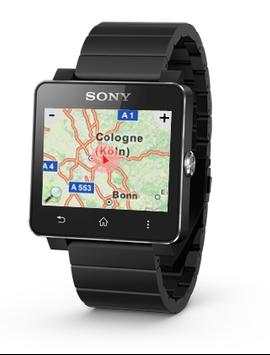
Does show Open Street Map on your smartwatch with your position marked with the GPS-Data of your Phone.
This is currently in an early development state.
Currently only running on the Sony SmartWatch2.
from version 2.0.2.1 on it supports offline maps in the format .mbtiles.
A map-file can be selected in the settings using the Smart Connect app.
.mbtiles can be created with for example Mobile Atlas Creator from http://mobac.sourceforge.net/
If you find any other problem please leave a message.
Swipe to scroll the map.
Press the or - button to zoom in or out.
Press the Menu button of the watch to open the menu:
Press Focus in the menu to focus again on your current position.
Press Find Car to find a route to your parked car fully automated.
Press Show route to find a route to your configured address.
Find Car fully automatically detects and remembers where you have parked and displays the route.
The App does not need to run on the watch for parking detection.
Find Car feature is powered by Anagog Location Based Services.
When the menu was opened the screen refresh is stopped. Just touch once on the screen when the menu is closed to refresh again.
Smart Connect extension for SmartWatch 2
LiveWare extension for SmartWatch 2

![[Gear 2] Gear Maps - browse map on your smartwatch screenshot 2](https://i.ytimg.com/vi/9KiF1--cP2c/mqdefault.jpg)


v2.0.3.2
- updated libraries
- update for Android L


